
- Distance of tour : 86 km
- Levels : +1384 m,-1385 m
- Average slope: 2.1 %
- Distance of tour : 86 km
- Hardness of tour : Közepes
- Levels : +1384 m,-1385 m
- Average slope: 2.1 %
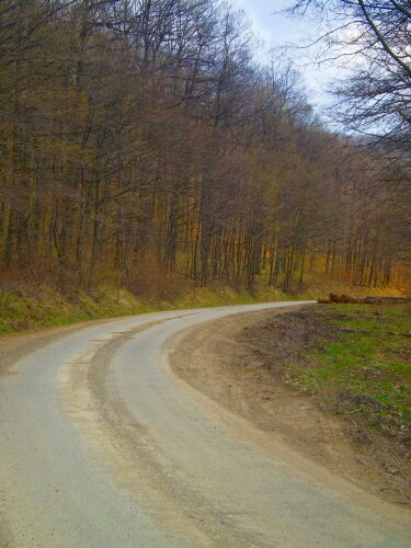
We cycle around the beautiful Vortex, which is not fulfilled with tourists, predominantly on forest asphalt roads and to a lesser extent on moderately trafficked highways. Vértes is a low, friendly, human-scale mountain, the route does not lead to high (up to 420 m), but there are short hills. The total elevation is 1116 m. But for anyone - for example people with children - doing just the easy first part, from Birkacsard to Vérteskozma and back, it's also an unforgettable experience! Caution on forest roads: wood cutting, machine and vehicle movement, mud application, sawdust and wood debris can be on the road! The road can also be used on a narrow wheel, although the road quality is mixed. There is a chance to meet wild animal, for example deers.
We depart from the Birkacsárda parking lot (not far from Tatabánya) which is near to the 44th kilometerstone of Route 1, towards Budapes. Biking on Route 1 is forbidden in principle, but the traffic is low, the road is wide and we only go 1 km, then we turn right into the forest road (barrier). Various bends, with slight elevations and slopes, easy part up to Vérteskosma (15 km). Meanwhile, there are two places to look out for: at 11 km, do not turn left but follow the main direction, and after the long straight part of the road, do not turn right at the small iron bridge - we will head towards during the end of the tour.
At Vérteskosmos, at the Delta junction, we get to the highway of the village (it is worth to go right into the uniform nice village, you can find a well near the temple), to the left. After an uphill part, fast slopes lead us to the Csávár-Oroszlány highway. We turn to the left, but only for 1 km, there at right angles to Gánt.
Great slope on a brand new smooth asphalt! At Gánt there is a good restaurant and water access. We continue on the slight slope of the highway until a roundabout, then we turn right towards Csákberény (left, the road can be shortened through Csákvár and Szár).
Before reaching Csákberény, we turn to the forest asphalt road to the right of a left bend. After a short uphill and downhill, we get to Pátrácos in the Horog Valley. There is a dead end to the left, but we go straight down - a good slope, but sometimes potholed! From the right hand side, the first small asphalt road is a dead end (it leads to a small mine, which can be a nice resting place), but at the second we turn right (to the left we would reach Pusztavám). Our road turns roughly north-easterly, with a straight trunk at one or two falls. Once again, we get to the Oroszlány-Csákvár highway, leaving the Kővaskás we turn left towards Vérteskosma, where we just came.
Before the village, we turn to the right at the barrier to the forest road (green cycling sign), after a few bends and a sloping straight line, there is a small iron bridge on the left - now we go that direction. Get onto the Ebijesztő-tető, then downhill. From the left you will find the Matthias Fountain, one of the few springs in Vértes – we can fill our water bottle!
After a little time we get off on an asphalt road, then we turn to the right towards Tatabánya and we follow that direction roughly on the outskirts of the city to Road 1. All you have to do now is to follow that - sneaky uphill part back to the Birkacsárda.
Most of the road is shady. We can refresh ourselves and get some water just in Vérteskozmán, Gánt and at the Matthias Fountain. Recommended help: tourist map of Vértes, 1:40 000, Cartographia.
Ajánlott kiadványok
 Turistatérképek |
 Túrakalauzok |